
The Netherlands has one of the largest and densest cycling infrastructure networks in the world. Where are all the Dutch bicycle paths located?

Like this map and want to support Landgeist? The best way to support Landgeist, is by sharing this map. When you share this map, make sure that you credit Landgeist and link to the source article. If you share it on Instagram, just tag @Land_geist. On Twitter tag @Landgeist.
I’ve posted quite a few maps here by now, but I’ve never posted a map dedicated to my own country, the Netherlands. What better topic to pick about the Netherlands than bicycle paths.
The Netherlands has some of the best cycling infrastructure in the world. Cycling is a very common way of getting around, especially for short distances. The geography of the Netherlands makes it perfect for cycling. It’s relatively flat and has a high population density.
In my opinion, cycling is the best way to get around a city in the Netherlands. It’s cheap, easy and free to park and often even faster than a car. You don’t need to worry about traffic jams and due to the excellent cycling infrastructure, you can often take slightly different routes than cars, which include some time-saving shortcuts.
I’ve seen maps about bicycle paths in the Netherlands before, but they seem to confuse the ‘fietsknooppuntennetwerk‘ (node cycle network) with actual bicycle paths. the fietsknooppuntennetwerk is a network of recreational bicycle routes that cover the whole country. These routes follow any type of road, which partially includes bicycles paths. However, it does not include all bicycle paths. As we can clearly see on my map, there are far far more bicycle paths in the Netherlands than routes of the node cycle network.
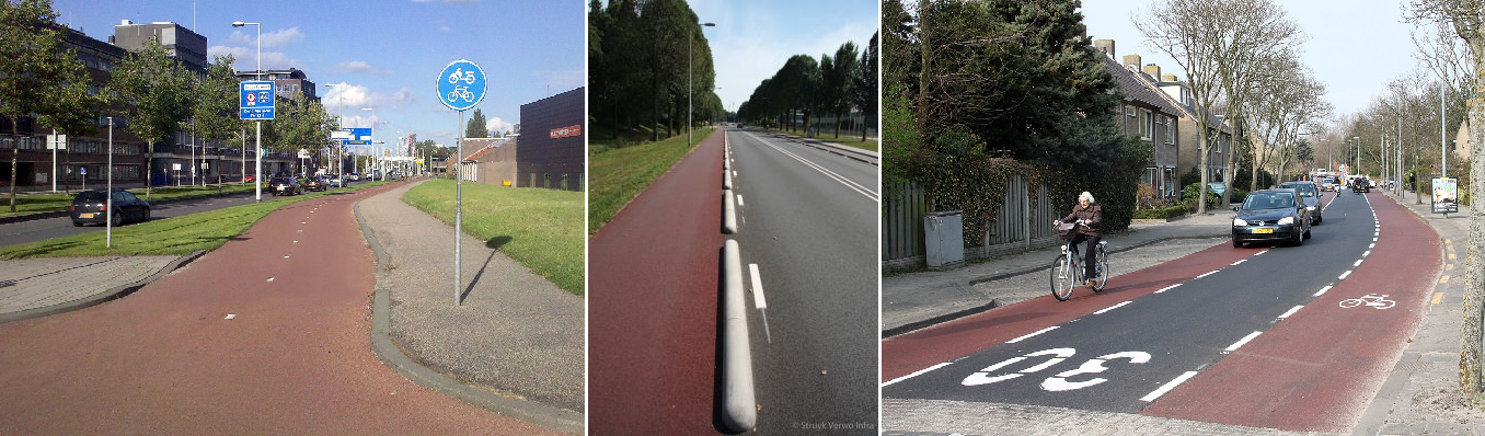
So what is included on my map? On this map you see all designated bicycle paths in the Netherlands. These are bicycle paths that are physically separated from other traffic (excluding scooters and pedestrians). This can be bicycle paths where the road surface is physically separated from the rest of the road, like in the left picture. But it can also be bicycle paths that are only separated by a small concrete barrier or poles, like in the second picture. Bicycle lanes, like in the right picture, are not included in this map. There are probably more bicycle lanes than designated bicycle paths in the Netherlands, but there is very little data on this in OpenStreetMap. I’ve therefore decided to not include them. I personally also think designated bicycle paths are a better indicator of good cycling infrastructure than bicycle lanes.
The data for this map comes from OpenStreetMap. Please be aware that it could be possible that some bicycle paths are missing. OpenStreetMap data is usually fairly accurate, but depending on the country, it could be somewhat incomplete. From my experience, OpenStreetMap is highly accurate and detailed for the Netherlands. However, it could be that some very new bicycle paths are missing. As this dataset contains a massive amount of bicycle paths, it’s impossible to check every single one of them with the satellite images. However, I did some random checks and I’m fairly confident that 99% of the designated bicycle paths in the Netherlands are included in this map.

Nitpicking about something that doesn’t even matter for your map: the image on the right does not show bicycle lanes, but “bicycle suggestion lanes” (fietssuggestiestroken) that have no formal meaning: a car could legally drive there. For a lane to be a bicycle lane, it has to have the bicycle markings.
LikeLike
Hi Juerd,
Thanks for pointing that out! I didn’t notice at all that the example on that picture didn’t have a bicycle marking on it. I’ve changed the picture, so it shows a better example. But it indeed doesn’t really make a difference for the map.
LikeLike