A new Earth-viewing satellite sensor that can observe both natural and artificial sources of visible light at night is providing a treasure trove of high-quality information for scientists, meteorologists, firefighters and city planners. The Day Night Band (DNB) sensor is so sensitive it can measure the glow of a single streetlamp from its vantage point 800 kilometers above. With moonlight, the DNB can observe clouds, snow and sea ice in almost as much precision as conventional daytime observations. Even on moonless nights the sensor can detect high-altitude pressure waves that modulate the atmosphere’s own faint glow.
I have presented several major applications of this new technology in “Night Watch” in the May 2015 Scientific American. A few additional capabilities that emphasize human factors are highlighted here, which further demonstrate how the DNB is helping research and operational communities by land and sea. (Details about the DNB—part of the Visible Infrared Imaging Radiometer Suite flying on the Suomi National Polar-Orbiting Partnership satellite—can be found at http://www.mdpi.com/2072-4292/5/12/6717). Overall, the DNB is helping us realize that nighttime is nowhere near as dark as we might have thought—and that we no longer need to be “in the dark” when it comes to operating in the nocturnal environment.
Squid boat shuffle
On supporting science journalism
If you're enjoying this article, consider supporting our award-winning journalism by subscribing. By purchasing a subscription you are helping to ensure the future of impactful stories about the discoveries and ideas shaping our world today.
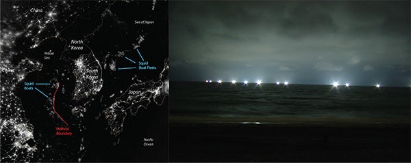
The vast network of electric lights at night shows how connected civilization is to Earth as an organism. But it can also provide poignant commentary on the current state of human divisions. Sharp changes in regional lighting often delineate areas of poverty and economic prosperity, which is perhaps nowhere more prominently displayed than in the juxtaposition of mostly dark North Korea and well-lit South Korea (center of left-hand image).
Squid boat fleets sometimes remind us of our divisions as well. The DNB can detect individual boats, each appearing as a point of light against the dark ocean water. The vessels use high-powered lamps to attract squid to the surface, like moths to a flame (right). The boats typically cluster in groups that follow schools of fishes from one night to the next. Sometimes the orientations of the clusters they form are tied in a benign way to natural features such as sea-surface boundaries that help form productive waters. But in the Yellow Sea and East China Sea regions we can see that these boats often abut political boundaries that define zones of shared (provisional) and exclusive fishing rights for China, Korea and Japan.
According to local people, there are two possible reasons for these unusual alignments: One has to do with boats of another country attempting to get as close as possible to waters having more squid. But another is purely political—the density of ships along these borders effectively blocks access to the “shared” waters, and could be a passive display of force related to territorial disputes among the surrounding nations. It is a cold war of sorts but also a wet one, as coast guard ships use water cannon to ward off fishing vessels. Agencies in South Korea, Japan and Thailand as well as Peru, Argentina and Britain are now regularly requesting Day Night Band data to see if boats are fishing illegally.
Ship trails, not contrails
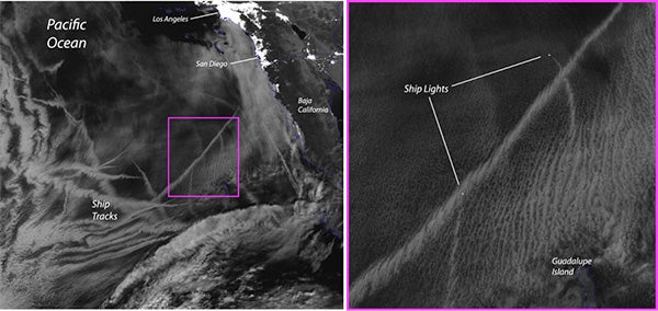
In less contested waters we see interesting effects of the maritime community at night as well. We are all familiar with how the exhaust from jetliners alters the atmosphere, forming clouds called contrails—those thin, white streaks across the sky. Recent research has shown that contrails can be significant enough to suppress sunlight hitting the ground below. The exhaust of ships is associated with similar effects; the effluent modifies the marine boundary layer—clouds in the very low atmosphere.
The DNB readily detects these “ship trails” at night. The left-hand image shows how effluents alter cloud microphysics off the coast of Baja, Calif. The particles of smoke act as focal points for water condensation, leading to a great number of additional small cloud droplets, forming tracks that appear from above and resemble aircraft contrails. The details of these tracks can be seen in the right-hand image; a trace of the ship’s path is formed. The bright point of light at the head of each track is a ship’s lights when the satellite flew over and captured the image.
The ability to observe these changes in clouds is more than an interesting commentary on ships passing in the night. Like contrails, the ship trails have some important ramifications for climate. Clouds reduce sunlight reaching the surface during the day and hold in surface heat at night. Changes in the properties of clouds triggered by air pollution can alter Earth’s heat budget; even minor changes to clouds can yield a significant impact.
Sleepless in Las Vegas
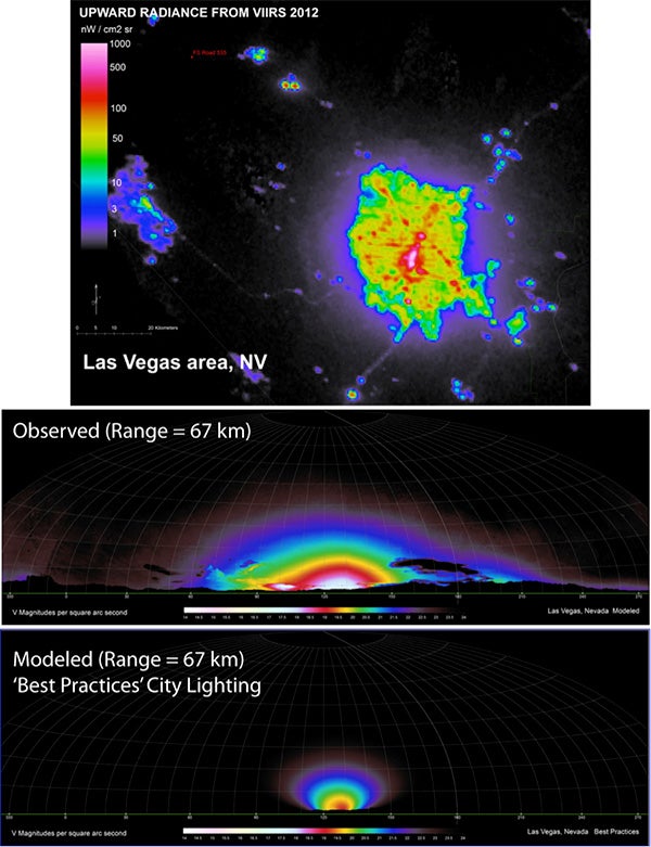
Perhaps the most striking images from the Day Night Band are city lights from around the world. They appear most often as mottled patches of concentrated brightness, although the sensor can separate out each pixel. The amount and intensity of the lights have been linked to economic activity and (obviously enough) power consumption, and the data is starting to be used in models that track carbon dioxide emissions.
Light “pollution” is also of growing interest. It significantly affects the migration, predation and even physiological functions of nocturnal wildlife as well as disrupts attempts by astronomers to survey the skies above. Researchers are starting to use DNB data to help planners reduce light pollution from major cities. They begin with a measurement for skyward radiance of the city’s lights, which the sensor can determine at great spatial and intensity detail (top image, of Las Vegas). They then use the data in models to simulate a “light dome” over the city and confirm that it accurately represents actual observations (middle image). The researchers can then manipulate the model to simulate how the light pollution would be reduced if buildings and roadways used lights that were shielded so they do not produce so much upwelling light into the atmosphere (bottom image). Such information helps planners gauge the impact of a given lighting strategy and improves our stewardship of the environment.
Faster search and rescue
Because the light from cities remains more or less stable from one night to the next, changes stand out readily in DNB imagery. Whether it is a power outage caused by a storm or destruction of lit buildings in war-ravaged Syria or the installation of holiday lights around Christmas and Ramadan, the DNB offers a unique perspective.
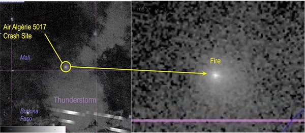
Sometimes a single, solitary light speaks to immeasurable tragedy. On July 24, 2014, Air Algérie flight 5017, carrying 110 passengers and six crew members, fell off radar after the pilot requested a diverted route around a thunderstorm. The plane crashed, killing everyone onboard. The Suomi satellite, carrying the DNB, happened to cross over the area within minutes of the crash. It captured flashes of lightning in a strong thunderstorm complex, and north of the bad weather it found the glow from a lone point-source of light in an unpopulated expanse of south-central Mali. The location of the light source matched exactly with reconnaissance of the crash site the following day; the DNB had detected fire from the burning wreckage.
To draw a small ray of hope from this tragedy we might imagine a future in which low-light sensors like the DNB are carried on geostationary satellites that blanket the world. Measurements would be updated over a region every few minutes, which could direct search and rescue teams toward the scenes of disasters—perhaps, in some cases, in time to save lives.
For additional reading:
DNB Overview: http://earthobservatory.nasa.gov/Features/IntotheBlack/
Fishing Boats: http://earthobservatory.nasa.gov/Features/Malvinas/
Holiday Lights: https://www.nasa.gov/content/goddard/satellite-sees-holiday-lights-brighten-cities/
Air Algérie Crash: http://cimss.ssec.wisc.edu/goes/blog/archives/16262