It can often be challenging to find alternative viewpoints of Africa. Perceptions of the continent are so colored by decades of stereotyped coverage and biased academic study that it can be hard to sift through the misinformation to understand the reality.
Often that search requires taking a step back. And now there’s a unique and literal opportunity to do so, via a new image and video library database launched by NASA this week. The site pulls together more than 140,000 images, videos, and audio files from 60 NASA collections—some of them decades old—for the public to explore, download, and use for the first time.
These images, culled from uploads and popular image searches of “missions in aeronautics, astrophysics, Earth science, and human spaceflight,” offer an often unseen view of Africa’s geographic beauty—without commentary.
A natural color satellite image of Africa’s fourth largest river, the Zambezi, taken in 2013.Image: NASA/JPL
An almost uninhabited region of northwest Sudan is pictured in 1994.Image: NASA/Johnson Space Center/
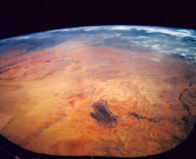
The ancient Richat Structure in northwestern Mauritania, also known as the “Eye of the Sahara” was captured by astronauts aboard the International Space Station in 2014. It is a nearly perfect circle, and scientists are unclear whether it was formed by an underground volcano or a meteor impact.Image: NASA/Johnson Space Center
The Canary Islands, just west of Africa, are pictured under a swirl of clouds in 1991.Image: NASA/Johnson Space Center
A 1992 photograph from the Space Shuttle Endeavour shows deforestation in the Democratic Republic of the Congo (then Zaire) in 1992. The light green areas are farmland, which contrast with the dark green of the surrounding canopy forest.Image: NASA/Johnson Space Center
Channels of the Okavango Delta stretch out into the desert in this view from the International Space Station in 2011.Image: NASA
A 1993 image captures a view of the Nile River, the Eastern Mediterranean, the Euphrates River, and the Dead Sea.Image: NASA/Johnson Space Center
South Africa is captured at night in 2014 from the International Space Station.Image: NASA/Johnson Space Center
The collection’s space radar images also illuminate with color the richness of Africa’s terrain.
The undulations of the the Roter Kamm impact crater in southwest Namibia are pictured in 1994. The crater is believed to be about five million years old.Image: NASA/JPL
The Atlas mountains in Morocco shown in a space radar image in 1999.Image: NASA/JPL
While efforts are underway to improve maps of Africa, we have NASA to thank for images that give us an accurate perspective of the continent’s place in the world.
Africa shown in 2015, one million miles from Earth, in a picture taken by the Deep Space Climate Observatory satellite. The picture is a combination of three separate images of the entire Earth taken a few minutes apart.Image: NASA/Goddard Space Flight Center
📬 Sign up for the Daily Brief
Our free, fast, and fun briefing on the global economy, delivered every weekday morning.