Dr. Philip Riris from the Institute of Archaeology at University College London and colleagues have mapped a series of rock engravings (petroglyphs), some of which are thought to be up to 2,000 years old, in the Amazonas state of Venezuela.

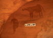
Aerial photograph of monumental Cerro Pintado petroglyphs. Image credit: Philip Riris, doi: 10.15184/aqy.2017.152.
The Venezuelan petroglyphs are located in the Atures Rapids area of the Amazonas state, historically reported as the home of the native Adoles by Jesuit priests.
They include depictions of animals, humans and cultural rituals.
One panel is 304 m2 containing at least 93 individual engravings, the largest of which measure several feet across. Another engraving of a horned snake measures more than 100 feet (30 m) in length.
Dr. Riris and co-authors used drones to photograph the petroglyph, some of which are in highly inaccessible areas.

Oblique aerial view of western panel on Picure, with interpretative overlay of main engravings. Image credit: Philip Riris, doi: 10.15184/aqy.2017.152.
“The Rapids are an ethnic, linguistic and cultural convergence zone,” Dr. Riris said.
“The motifs documented here display similarities to several other rock art sites in the locality, as well as in Brazil, Colombia, and much further afield.”
“This is one of the first in-depth studies to show the extent and depth of cultural connections to other areas of northern South America in pre-Columbian and Colonial times.”
“The size of some of the individual engravings is quite extraordinary.”
Almost all of the engravings found in the Rapids are inundated and exposed to varying degrees by seasonally rising and falling water levels in the Orinoco River.
Depending on fluctuating upstream precipitation, the relative height of the river also varies annually by up to several feet during the extremes of both seasons.

Six human figures on the western panel of Picure, including a flautist. Inset: polynomial texture mapping detail of flautist. Image credit: Philip Riris, doi: 10.15184/aqy.2017.152.
“In one panel surveyed, a motif of a flautist surrounded by other human figures probably depicts part of an indigenous rite of renewal,” the researchers said.
“Performances conceivably coincided with the seasonal emergence of the engravings from the river just before the onset of the wet season, when the islands are more accessible and the harvest would take place.”
“Mapping the rock engravings represents a major step towards an enhanced understanding of the role of the Orinoco River in mediating the formation of pre-Conquest social networks throughout northern South America,” added team member Dr. José Oliver, also from the Institute of Archaeology at University College London.
The results of this research are published in the journal Antiquity.
_____
Philip Riris. 2017. On confluence and contestation in the Orinoco interaction sphere: the engraved rock art of the Atures Rapids. Antiquity 91 (360): 1603-1619; doi: 10.15184/aqy.2017.152