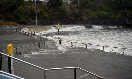
Torrential rain in New South Wales has reduced the number of active fires in the state by a third, from more than 60 down to 42, but parts of the east coast now face a new threat from flooding, with Sydney facing one of its wettest three-day periods in years.
The commissioner of the NSW Rural Fire Service, Shane Fitzsimmons, said on Friday there had been a “dramatic shift” in the hot, dry and windy conditions that have driven the unprecedented fire season for months.
“This has been an absolute welcome disruption to that weather pattern and a massive reprieve and relief to so many people right across New South Wales,” he said.
“Obviously we don’t want to see lots of widespread damage and destruction from flooding, but it is certainly a welcome change to the relentless campaign of hot, dry weather resulting in widespread damaging, destructive fires that we’ve experienced for too long now.”

The RFS is taking advantage of the conditions to strengthen containment lines and, where possible, conduct back-burning operations.
Fitzsimmons said of the 42 fires still burning in NSW, 17 were uncontained. He said there was optimism that rainfall over the next week would result in many of those being declared contained, and “hopefully going to the status of out”.
The largest effect has been on fires in the north and north-east of the state.
“It’s certainly not across all the fire grounds at this stage. We’ve seen it concentrated largely up through the north-east of the state, it is slowly moving south-eastwards toward Sydney and parts of the Illawarra,” Fitzsimmons said.
Coastal areas of NSW, including Sydney, could receive their highest rainfall levels in more than three years as a trough makes its way down the state.
Multiple severe weather and flood warnings were in place across NSW on Friday, with emergency services warning of possible land slips in areas near fire grounds cleared of vegetation.
Not sure Wakehurst Parkway should still be open? #sydneyrain pic.twitter.com/9my5SHpp09
— Stephen Spencer (@sspencer_63) February 7, 2020
The Bureau of Meteorology said on Friday could see Sydney receive its largest amount of rainfall over a 24-hour period since 2018, with 60mm to 90mm forecast. Totals as high as 200mm were forecast for Saturday, and 150mm for Sunday.
The last time the city had more than 100mm of rain in one day was 28 November 2018.
The city could also receive more rainfall over a three-day period than it has has at any point in the past three and a half years, with as much as 120-150mm forecast for Saturday and another 90-150mm expected on Sunday.
“The last three-day event when we saw rainfall totals potentially this high was 226mm and that was in June 2016,” Dean Sgarbossa, a senior meteorologist, said.
The heavy falls are due to a trough that is making its way from south-east Queensland and northern NSW down the coast. The bureau warned conditions were likely to develop into an east coast low, which can be characterised by “destructive winds, torrential rainfall and rough seas”.
Mitchell Harley, a coastal researcher at the University of NSW, said 5.5m waves forecast for high tide on Sunday morning in Sydney could potentially replicate conditions similar to the 2016 east coast low, when parts of houses in the northern beaches suburb of Collaroy were destroyed and large sections of the beach were washed away.
In Newcastle, 45 tonnes of sand were brought in to protect Stockton beach, the ABC reported. The beach has suffered dramatic erosion in recent years, forcing the closure of a childcare centre and threatening other beachside buildings.
Within the trough there are smaller low pressure centres that are leading to intense rainfall over some areas. The BoM said the small scale of these low pressure centres was making precise forecasting of rainfall levels in some areas difficult.
The heavy falls are expected to move into fire-affected parts of the NSW south coast over the weekend. There could also be significant falls in areas with active fires near the ACT and in Victoria’s East Gippsland region.
But those heavy falls come with warnings of water contamination from ash and silt.
Increased run-off could also lead to flash flooding and land slips, which may block access trails and roads in some areas.
WaterNSW has been monitoring areas around the Warragamba Dam, the source of 80% of untreated supply for greater Sydney.
Two silt curtains designed to trap material that could pose a risk to water quality have been in place since January.
On Friday WaterNSW said the Warragamba catchment was expected to receive 200mm of rain over the weekend, but the advice from the Bureau of Meteoroglogy was that rain would not be at such a level as to raise major concerns about water quality in the Warragamba dam storage.
We’re really pleased to see #sydneyrain falling across our catchment. Please remember to continue to save water in your home and that severe water restrictions are in place. pic.twitter.com/mUnm748aFP
— Sydney Water (@SydneyWaterNews) February 7, 2020
“However some debris/ash is likely to be transported into the storage.”
The chief executive of WaterNSW, David Harris, said the organisation had sophisticated models that could predict what was coming into water storages. He said the full impact would be clearer in coming days.
“Managing water quality in our dam storages is what we as an organisation do, and our water quality scientists are highly-regarded experts. Some debris/ash is likely to be transported into the storage, but we are well-placed to manage the risk,” he said.
Brogo dam, on the south coast, which supplies Bermagui, is also close to a fire ground.
On Friday, the flooding led to road closures in some areas, including several in Sydney.
In the northern rivers region, a car was washed off the road and two people had to be rescued from a caravan due to rising floodwaters.
The road to the Jenolan Caves, south-west of Katoomba, was also closed due to fears the heavy rain could cause landslides.
The RFS said there were still some areas west of the ranges around Canberra, where a number of fires were burning and yet to see rainfall.
Crews were back-burning where possible, but very heavy rain could make that difficult in some places.
However, Fitzsimmons said the wet weather was putting much needed moisture back into the landscape and this would help firefighting efforts, even if hot, dry weather returned.
“We’re certainly not going to have the underlying conditions of such profound moisture deficit and drought situations dominated by this massive heat event that’s been sitting there literally for months,” he said.
